The Flume Gorge
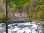


The first stop of the day today was in Franklin, which was close to where I had stopped for the night, and I had read that the town had a nice multi-purpose trail. I didn’t know where it was, but figured I’d run across it by walking around town (note to myself: look BEHIND my parking place, and sometimes what I’m looking for is right there!). Franklin was a thriving paper mill town back in the day, but now there are some empty storefronts in Main Street. I walked out by the train station – long trails sometimes seem to be along railroad tracks or rivers, but I didn’t see anything. So we then walked around the hilly town, and stopped in the little park at the other edge of town, and that’s when I saw the start of a trail under a train trestle. So Tula and I headed over and it was a wonderful wide path, and it took me a little while to realize it was another rail trail. After about the first half mile or so, I was happy to see a sign describing the “upside-down covered bridge” that was visible a little farther ahead. It was a train bridge (no longer used of course) and all the trusses and supports were beneath the tracks, so they enclosed all of that to protect it from the weather, plus capped the ends, and didn’t have to worry about the iron tracks on top. So it’s the only upside-down covered bridge still standing, even though the planks that covered the trusses are no longer there – some of them was destroyed by fire which they suspect was arson. A little farther up the river were some remnants of the footings of the old mills. With a big fast-flowing river, and railroad tracks, and bustling paper mills, it’s no wonder Franklin was a prosperous town in it’s day. Altogether I walked 3 miles on that trail (and another mile in town) and for 2 of them I could see and listen to the Winnipesaukee River with all it’s whitewater – wonderful background music! And that’s why I don’t listen to an iPod while I’m walking – I want to hear my surroundings!
When I came off the trail, I read the plaques under the train trestle, and then decided to read more about the project on the computer. The trail is about 3 miles long one way and people can access the trail from 3 different communities. Part of the reason the communities decided to make the trail was to fight their own battles with obesity and lack of exercise. And they decided an easily-accessible trail could help. There’s still work to do, and they had just held a fundraising event the night before. Although I was planning to do a food pantry donation today (but no one answered the phones when I tried calling), I changed my mind and decided to make a donation to the Winnipesaukee River Trail Fund. Not only was the trail really nice, but the reasons behind it were good ones, and I was really happy I found the trail.
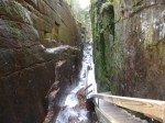
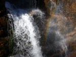
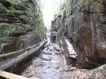
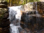
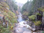
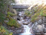
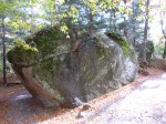
Then, since the sun was sort of out and it wasn’t raining, I decided to head north again into the mountains – I wanted to go to the Flume Gorge State Park. I had heard the trail through the gorge was spectacular, and although it’s only a 2 mile hike altogether, it involved lots of hills and lots of steps – walking down into the gorge and back out. So I got my ticket for the walk, and it was cold in the mountains – I had on my fleece, a windbreaker, a hat and fingertipless gloves so I could still take pictures. As soon as I started the walk (they have a bus that take people partway in if they want – but I just walked the whole way), white pellets started falling – I don’t know what it was – frozen snow maybe?? It wasn’t rain; it wasn’t snow; it wasn’t sleet – it was just white pellets – falling fast! The walk through the gorge truly was spectacular, and the park had built narrow boardwalks and steps along the side of the gorge above the river. Up until about the mid-1800s there also was a huge boulder wedged in at the top of the gorge (they had photos of it) and then it came crashing down during a violent storm. Going through the gorge took about the first half of the hike, and the rest was through other parts of the state park, including a huge “boulder garden” – the size of some of the boulders that the glaciers deposited there are pretty amazing. It was such a pretty hike that I decided to do the whole thing again. I was a little tired after the second go-around! Tula had to stay in the car, which was fine – dogs weren’t allowed on that trail for very good reason! The visitor center also had lots of articles about the face if the “old man of the mountain” falling off in May 2003 – it really made a lot of people around here sad. It was snowing by then (real big, pretty flakes) and once again, I knew there would be no camping tonight. I did get to see some mountaintops on the hike though – some bare granite spots up high, and snow up there too.
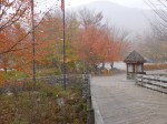
After 4 miles of up and down walking, I was more than happy to sit in the car and head to the south part of the state. As we went through Concord, the capital, it was just about disk, and the Capitol dome was all lit up, and it was a pretty part of town, so I got Tula out for a mile and a half walk, which gave me 9 1/2 miles for the day – I’ll use the extra mile and a half on Monday, since I didn’t get any New Hampshire walking done last Monday. Then we finished the drive to Nashua and called it a day

We at the Winnipesaukee River Trail Association would like to thank you for the donation and are so happy that you enjoyed our walking trail. Sorry you weren’t here in time to go the Taste of the Trails fund raiser and get to meet all of us. Am enjoying reading your blog and looking forward to the rest of your trip.