Mississippi – Tuesday, December 4
Since I was in Natchez, I wanted to check out the Natchez National Historical Monument, home of Melrose Plantation. It was nearby, but one of the rangers had called in sick, and they weren’t doing the plantation tours til later. But I was able to wander around the grounds, the gardens and the slave cabin area. One of the other rangers, who said he is not usually a flower person, said that when all the magnolias are in bloom in April, even he’s impressed. The magnolias still have green leaves, but they have dropped their seed pods – about the size of pine cones with red seeds inside. I wished it could be April for about an hour so I could see everything in bloom!
Then we got in the car and headed east – I didn’t really have a plan today, and knew I’d have to make a decision in about an hour whether to try to head down to the very southern part of the state by the ocean, or if I should gradually start making my way to the northern side. While I was thinking and driving, I passed Okhissa Lake Recreation Area which was part of the Homochitto National Forest, so I turned in and discovered my national park pass also gets me in to National Forest areas. The lake here is popular for fishing, but there was also a path leading around it and alongside the woods, and Tula and I got in almost 3 miles of walking. And I knew that if I tried to head south to the ocean, I would probably be trying to squish too much into too little time! And, even though Hurricane Katrina happened more than 5 years ago, they’re still working on getting everything re-built, although it sounds like they’ve made a great deal of progress. So I continued heading east with Hattiesburg as my new goal.
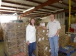
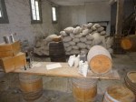
Along the way I stopped in McComb to see if it would be a good town to get a few more miles of walking in. But I thought I better look into my donation-for-the-day too, so I got on the computer to see if there were any food pantries in McComb, and discovered there seemed to be several programs run by the St. Andrew Ministries – S.A.M. for short. They have a couple buildings around the corner from each other, and I found them and went into the food pantry to see if there was anything in particular that they needed. When I visit food pantries when they’re open to the public, people usually (understandably!) think I’m coming in to get some food – then they’re usually happy to find out I can bring them some instead! I talked with the volunteers there, and they told me their food pantry serves seniors and people with disabilities, because they don’t want to duplicate services that other organizations help. They’re trying to make sure no one falls through the cracks. They also operate SAM’s diner, which provides a free homecooked meal to anyone who needs it, and they also have a thrift store to help fund their programs, and a health clinic. They’re working on a senior center too, so that seniors will have a place to meet and socialize. So they have a lot going on and I was happy to find them! They were in need of soup, canned meats like tuna and chicken, and hot and cold cereal. So I went shopping and got a bunch of that stuff and brought it back. Then we went outside for a couple pictures. I had wanted a close-up of their sign, but forgot to get that one, so it’s just visible over the shoulders of the volunteers.
Then I moved on, belatedly realizing I didn’t get any walking done in McComb because I was shopping and talking to the people at SAMs! But I soon passed Bogue Chitto Water Park (water refers to the river, not an amusement park!), one of Mississippi’s state parks, and they had some nice lanes to walk on through the park. It was kind of a damp misty day, and I stuck to the paved lanes instead of the trails in the forest through all the wet leaves. We walked all around the park and through the campgrounds and I only saw a couple people. There’s a river with a boat ramp where people often fish but it just wasn’t a great day to be outside! I didn’t mind though – it was pretty in the mist, and I finished up my walking for the day just as it got dark.
I had about an hour’s drive into Hattiesburg, which was my stopping point for the night.


Mississippi – Monday, December 3
Since I spent the night in Vicksburg, I had researched some food pantries, and had found one called Storehouse. They had a nice website that indicated they were open on Mondays, and they also had a wish list of items they could use. So I took the wish list into Kroger with me, and did my shopping. I got mac and cheese, rice, peanut butter and jelly, tuna, canned ravioli, grits (first time I’ve seen grits on a wish list!), oatmeal and cereal. They also wanted Jiffy corn muffin mix, and I always like to include that anyway, since it’s made in my hometown! Then I found the food pantry and walked in to see where I should bring the groceries. They had me sign in, and let me use a shopping cart that made it easy to bring all the bags in. There were 4-5 volunteers working and they were all really nice. They were helping a couple families, but after they left, things were quiet for a few minutes, which isn’t usually the case on a Monday morning! So I had a chance to talk with several of the volunteers – one of them told me how happy they were with their new location which had both heat and air conditioning (in the past they’ve had one or the other which is not ideal). Another one showed me around – their space is clean and very well organized, with shelf space labeled for different groups of groceries. They have an “overflow” space which had food in it now, but the volunteer told me that although they’re in reasonably good shape now because of people’s generosity during the holiday season, there will probably be slim pickings come next April or May. And I’ve heard several people make comments to that effect – people think of the homeless and hungry during the holidays, and don’t always remember them during the rest of the year when the need is still great. Summer months can be tough for food pantries. They also have lists of what to provide the families with who come to them – and it’s mostly based on family size. They are considered an emergency food pantry – families may visit 3 times a year when things get extra tight; it is not meant for weekly use. I enjoyed talking with them.
As I was leaving, another volunteer suggested I might want to walk down by the Mississippi River again to enjoy all the murals on the town side of the levee walls. So Tula and I did that – I could tell last night that there was some artwork down there, but couldn’t see it at night. There were about 20 big murals and it made a nice art walk. I also went thru an opening to the river side of the levee, and my mind simply cannot comprehend the high water marks on the levee. The river was still a little below me, and to think of all the water that would have to pour into the river to bring levels way over my head is almost unbelievable. But it has happened. The town also had a tornado memorial from a devastating tornado back in the 50s. But Vicksburg is still there – through Civil War, tornado and floods!
Then I shopped for my 2nd donation of the day. I had also read about a food pantry down in Natchez called The Stewpot, and I liked that name! Since I was headed in that direction, I contacted them, and they said they would be happy to get anything I would like to bring them. But Natchez was a little farther away than I thought (and I may have lingered a little too long in Vicksburg!) and in the end I knew I was not going to get there by the time the food pantry closed at 2:00. I called then to say I was going to be late, and if they would like, I could drop the groceries off the next day. But the lady told me she would make arrangements to have someone there when I arrived, and I got there about 1/2 hour after the food pantry had closed for the day. I went around to the back as instructed, and 2 younger people met me back there, and they carried the food into the building, then came back out to wait for their ride. So I didn’t really talk with anyone there.
Tula and I had a lot of walking to do since we had only done about a mile back in Vicksburg. And fortunately Natchez was a wonderfully walkable city. I got a map at the visitor center, and Tula and I walked up and down all the streets in the historic part of town, and out into several neighborhoods. I walked past several stately antebellum homes, and through other neighborhoods where flowers on trees were still blooming and it smelled so good. There was also a long river walk by the Mississippi River and we walked the whole length of that; both along the topside of the levee which was parklike, and then down by the river which was more like a nature trail. Again, those levees are 20-30 ft tall and I just can’t get my head around that much more water in the river! The trail by the river had nice signs periodically describing the local flora and fauna and they were fun to read – until I got to the sign about the varieties of venomous snakes in the area. I quickly left the river trail and got myself back up to the top of the levee! By this time it was beginning to get dark, and the park had a lot of mechanical Christmas displays that were all lit up and it was a festive way to finish up walking. We walked 7 miles all over Natchez.
Since it was relatively warm out, I was hoping to camp tonight, and there were 2 campgrounds kind of close. One of them was a state park, but the website had reviews that they allowed in-season hunting, and since I didn’t know who might be hunting for what, I decided that wouldn’t be a good choice. The other one campground looked good on the website, but quite different when I arrived! I decided it would be a motel night after all, so I stayed put in Natchez; ready to head east in the morning.


Mississippi – Sunday, December 2
This morning I headed south toward Vicksburg – driving through the very flat land of the Mississippi Delta. There were lots of big, plowed fields, and I’m guessing they’re rice fields. As I approached Vicksburg though, the land quickly became hilly. I was headed for Vicksburg National Military Park, which will be the 4th military park I’ve visited. They seem to be ideal for walking – one lane roads with very light traffic (most are set up for pedestrians in addition to vehicles) and rolling hills (good cover for battles), and sometimes monuments and old cannons and all to look at too. Vicksburg NMP is not only a military park, but has also turned into a park with a lot of art – 1300 sculptures, monuments, plaques, etc. There’s literally something around every bend. I learned that the civil war battle at Vicksburg is right up there with Gettysburg in terms of pivotal Civil War battles. Nearly every state that was part of the country back then had soldiers in this battle – 100,000 of them. Tula and I did all of our 8 miles of walking in this park, and admired many of the Union monuments. When this land became part if the national park system in the early 1900s, each state that had soldoers in the civil war battle was given permission to build a monument to memorialize their efforts. The Union states were quick to build huge, often elaborate, monuments (and often several smaller ones too)and they were placed in strategic areas in the park. This is a place where the soldiers who actually fought in the Civil War came back in the early 1900s to mark battle locations, so the actual history of advances and retreats is more comprehensive than many battle sites, and it’s very easy to see the Union and Confederate lines.
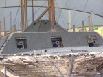
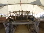
It was a very warm day (it hit 80) and I did my walking in roughly 3 mile chunks. After walking through a lot of the Union side of the park, I followed the road to the Confederate side. There was a very different feel to the park here – fewer monuments and much less elaborate. Then I read a sign that described the northern states jumped right on the opportunity to build (and perhaps try to out-do each other?!?) their monuments, but the southern states were so depleted of all resources that many of them had to wait a good 10 years or more to start work on their monuments. And by then architectural styles and work had changed, so the Confederate side is quite different from the Union side. Another site to see at the park was the USS Cairo museum – ironclad gunboats were favored in battles in the Mississippi River because they could be used in relatively shallow water and were effective in transporting soldiers, weapons and supplies. None of these gunboats survived…except for one that was raised out of the Mississippi mud 100 years after it sank, and it is now on display in the park. It isn’t quite intact, but it’s now preserved in a framework that allows visitors to walk inside part of the ship, and to try to imagine what it must have been like on the river. Lots of artifacts are in the museum – the boat sank quickly and although no lives were lost, everything else was until the wreck was discovered.
There is also a civil war national cemetery on the grounds, and Tula and I walked all around that too. There were quite a few plaques placed in different parts of the cemetery with pretty verse:
On fame’s eternal camping ground,
Their silent tents are spread,
And glory guards with solemn round
The bivouac of the dead.
Back at the main visitor center, I watched a good video of the battle and 6 week siege of the town, and the whole day was a wonderful educational experience as well as a good walking opportunity. Part of what all the memorials want to convey is not only recognition for those who served, but hopes that brothers, families, neighbors and friends will never again pick up arms against each other. The visitor center had a donation box with a sign explaining donations would be used for educational purposes, and there’s lots of lessons to be learned here, and I made my donation-of-the-day here. It’s a wonderful national park, with lots to see and learn.
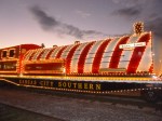
By this time, I had spent nearly the whole day at the national park, and thought I would drive into the town of Vicksburg itself. It was getting dark, but again, there were all kinds of people out and about down by the river. The Christmas Train had pulled into the train station, and the engine and all 6 cars were decorated with hundreds and hundreds of lights and there was a huge long line of people waiting to walk through the train. I asked a couple people what was inside the train, and they told me the different cars were full of really good Christmas displays, and well worth the wait. But, I’d been on my feet most of the day, and opted for a quick mile walk through the decorated Main Street instead before calling it a day.


Mississippi – Saturday, December 1
I crossed the Mississippi River into Mississippi, and was immediately confronted by riverside casinos. I’m not sure why they’re just on this side, and not the Arkansas side also. The sun was going down, and I hoped to at least get my first mile of Mississippi walking in, so I headed to downtown Greenville, hoping that Christmas lights were on, and that people were still out and about. And indeed they were. In fact, there seemed to be a lot of people, and then I noticed some police cars, and began to wonder what was going on. I was down by another area of the river, and pulled over to turn around, and suddenly a big fireworks show began, and I was in a good spot! It was a long fireworks show, and I asked some passersby what the occasion was, and they told me it was the December 1 kick-off for the Christmas season, and that there’d been a big parade earlier in the day. I enjoyed the fireworks, then walked through town a bit. I decided to stay in Greenville for the night, so I could sort of figure out which direction I would head off to in the morning. So…Hellooo Mississippi!!!


Arkansas – Saturday, December 1
Before I left the motel this morning, I talked with the voluntary services director at the Central Arkansas Veteran’s Healthcare System. It’s one of the largest and busiest VA medical centers and is considered a flagship of VA healthcare providers. The director wasn’t normally supposed to be in on a Saturday morning, but I believe he said he was showing Miss Arkansas around the facility. We talked about the wish list of items on the website, but he told me what they really needed at the moment was plain white t-shirts in a variety of sizes. I told him I would stock up on them and bring them by, only to realize that this particular facility was in Little Rock, not in Pine Bluff where I was (I think the Pine Bluff website is tied in with the main one in Little Rock.) Little Rock was the exact opposite direction from where I was headed, and I simply couldn’t get up there, so I told him I’d send a donation check instead, and he said that would work out just fine. So that is my military-related donation for Arkansas.
Since I had camped a couple nights in Arkansas, I had a little money left, and was able to stop and get more dog food and treats for Tula, and a few groceries for me. I still had a bit extra and was happy to be able to buy some toys to donate to the big Toy Collection that the Jefferson County Police were collecting for foster children. They had a big semi out in the parking lot along with some of the officers, and I was able to give them some sticker books, matchbox cars and Slinkys.
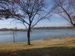
I headed southeast toward Mississippi, through lots of very flat farmland, and I think I was looking at rice fields. Most of the fields were freshly plowed – the rows were long mounds – so I’m not positive, but I know it’s a rice-producing region. I passed through a couple tiny towns, and none of them really had places where Tula and I could get out and walk. Then I came to Lake Village, right by a big oxbow lake, and there was a walking path (kind of in rough shape) along part of the lake, and long sidewalks through some lakefront neighborhoods, so we walked for a couple hours, enjoying the warm weather and the lake views, and got all 6 miles of walking done. The lake is 20 miles long, and used to be part of the Mississippi River, but when the river changed course centuries ago, this part of it somehow got cut off and turned into a lake.
Because of the Mississippi River, there are only 2 ways to drive into Mississippi from Arkansas, and about 15 minutes after finishing our walking, I said goodbye to Arkansas. Mission complete! Seven donations given (Turpentine Creek Wildlife Rescue-the big cats; The Little Chapel Food Pantry; Thorncrown Chapel; Northwest Arkansas Women’s Shelter; Mt. Comfort Church of Christ Food Pantry; Community Services Clearinghouse; and the Arkansas Veterans Healthcare System). And I walked 56 more miles – most of that with my new walking shoes, bringing my total number of miles walked to 672 since I began this adventure.


Arkansas – Friday. November 30
Tula and I started the day off with a mile walk around the campground, then headed to the visitor’s center for Hot Springs National Park, which is right in the middle of downtown Hot Springs. This national park preserves 8 large bathhouses from the early 1900s in addition to some if the hot springs. The bathhouses are all lined up along one side of Main Street and most have an elegant Spanish sort of style. Only a couple buildings are still used – one is the visitor’s center, and 2 still offer hot baths and other spa services. The 1920s were kind of the heyday of coming to town to take the baths, and there are still some grand hotels in town. A mile long Grand Promenade was built along the side of the mountain behind the bathhouses – it was a place to see and be seen, so visitors would dress in all their finery and the latest fashions from St. Louis to stroll along and take in the fresh air between soaks. Most of the springs are covered now to keep them clean and pure, but there were a few open springs in town, which were easy to find because of the steam. The water is 140 degrees, and I stuck my fingers in and it’s definitely hot! One kind of algae can tolerate the heat and it’s kind of a bright green. The water in these springs is clear and odorless and clean. There was a park ranger at one of the springs helping some kids with their Junior Ranger activities, and I listened to her tell the kids that the water that was trickling down into the spring was 4000 years old – it fell as rain around the time the Egyptians were building the pyramids, and then slowly (about a foot a year) seeped downward about 2 miles into the earth’s crust where it was heated, then ultimately pushed back to the surface by the arrival of more rain. It’s hard for me to comprehend that the water I was touching was 4000 years old. The video I watched talked about this cycle too, and also showed pictures of the valley before the springs were covered – the whole valley was full of steam, and was called the Valley of Vapors. It’s fascinating! Tula and I walked 5 miles – down Main Street past all the old bathhouses; walked the Grand Promenade from end to end; walked along the other trails off the Grand Promenade; and then walked over a mile and a half along the one-way auto route up to the top of Hot Springs Mountain, where there was an observation tower. Then we walked back down the mountain, and got a couple jugs out of the van to fill with spring water at one of the “faucet” areas in town. People would pull up and fill up crates of water jugs with pure spring water, and most of the souvenir shops sold empty bottles to fill up in case you didn’t have any of your own. The water that comes out of the faucet is still hot – and it stayed warm for quite a while! At this point, I was ready to sit in the car and continue heading east across Arkansas.
I didn’t make a donation today – the only one left is my military-related one, and I will take care of that in the morning.
After a short stop in Sheridan to walk our last mile of the day, I headed to Pine Bluff for the night.


Arkansas – Thursday, November 29
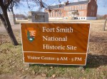
My donation-of-the-day today came about in a very unexpected way…a walk through town, which led to a historic fort and gallows, which led to a historic bordello, which led to my tour guide, which led to my donation! It’s fun when pieces fall into place like it’s meant to be! Tula and I started the morning off by walking through downtown Fayetteville as long as we were there. And as luck would have it, Fort Smith National Historic Site was actually right at the edge of town, and there were some nice trails through the old fort area and exhibits, and also down by the Arkansas River. One of the restored sites to see at the fort was a gallows. It was kind if creepy, especially because it was built to hang up to 6 people at a time. And I learned later that hangings were such a popular spectator event that tickets were issued to the people who were allowed to watch, and everyone else had to stand back. There was also a Civil War era national cemetery right by the grounds of the fort, and Tula and I walked through that too. It was very beautiful, and made me think of Arlington Cemetary. There were many graves of unknown soldiers and unknown confederate soldiers. I briefly considered going and getting some flowers to put at some of the grave markers for the unknown soldiers as my donation for today, but there were a lot if regulations as to how and where to place flowers and plants, and it didn’t seem practical in the end. A fun thought while it lasted. I also went to the visitor center for the fort and watched the video and went through the museum, and ended up buying a year-long pass for the national parks. I should have done this a while ago – some parks are free, and the admission fee for others isn’t much, but it begins to add up. And they’re good places to walk and absorb some history! Between the walk in town, and around the fort and trails, and through the national cemetary, Tula and I covered 5 1/2 miles.
One of the directional signs on the trails pointed the way to “Miss Laura’s” place, which turns out to be the only bordello on the National Register of Historic Places. It also serves as the visitor center for Fort Smith. I went in and apparently Miss Laura ran a very high class establishment, and the tour was really interesting. My tour guide asked where I was from, and where I was headed, and I briefly explained what I was doing. It turns out he is on the board of directors for the Community Services Clearinghouse in Fort Smith, and they pass out hundreds of backpacks with food in them every Friday for kids who might not get enough to eat on weekends. It sounded like a wonderful program, and I wanted to help, so he told me how to get there and who to ask for. The people at the clearinghouse were very friendly, and supportive of what I’m doing, and she took me all around the warehouse, and told me about all the programs they’re involved with. They have a lot of volunteers to help get everything where it needs to go. Besides the backpack program for kids, they also help low-income cancer patients, gather toys for underprivileged kids, and run a food pantry. The number of people they help in a 4 county area is amazing. My donation to them was a check – they can stretch the dollars farther than I can with their resources. Again, meeting people with such big hearts doing endless work to help soooo many others is so nice to see – I’m glad to have a teeny, tiny part in it all.
Then I headed for Hot Springs – I was going to be going through the Ouachita Mountains, and since it was going to be a couple hour drive, I didn’t want to wait until too late. The drive east was pretty, and I got I to Hot Springs just as it was getting dark. I found the historic part of town which was all decorated, and lots of people were out and about. The main street was long, and pedestrian friendly, and it was a fun place to finish up the walking for the day. I had decided to camp tonight even though it might be a bit chilly, and once I’d found a bite to eat, we made our way to one of the Hot Springs campgrounds and got set up. It got down to about 40, but I stayed cozy in the van with quilt and sleeping bag and pillows, and Tula has several layers of blankets too!


Arkansas – Wednesday, November 28
Today I was going to be heading south toward Fayetteville, and I wanted to make a food pantry donation. There were several food pantries in that area, and I decided to contact the people at the Mt. Comfort Church of Christ food pantry, because the street I grew up on was Comfort Drive, plus they were open on Wednesdays, so it seemed like a logical choice to me! I spoke with a lady at the church (the actual food pantry is in a separate building) and she said they would be happy to get any non-perishable goods. So I shopped for the food, and got a big variety of things, then drove south to Fayetteville. I dropped off the groceries, and the director came out and told me a little more about their program. He’s been involved with it since 1995, and they’ve been helping about 25 families every week, and had just finished helping a lady with 4 children. They appreciate the extra space they have now that the food pantry has its own building, which they named the Banford House after a longtime volunteer. It’s another organization doing good things for others.
By this time, I needed to get going with my walking. I was having a little trouble finding a good place to walk, but I knew there had to be something in a big college town! Just when I was thinking I would move on, I stumbled upon a long walking/jogging trail that went for miles. It started out going by lots of apartment complexes (Fayetteville is home to the University of Arkansas) before getting out into more open land. There were lots of people out jogging, walking, and biking – it was a pretty afternoon. Tula and I spent a couple hours walking and got in about 5 1/2 miles. As I was leaving town, I passed through one of the historic neighborhoods and walked another mile and a half.
Then I continued driving south toward Fort Smith through another pretty mountain range. The mountains are pretty in November even with all the leaves off the trees, and must be spectacular in the spring. We stopped in the historic area of Van Buren to finish the last mile of walking. It was a nice little town, but very quiet for only 5:30 at night.
Fort Smith was pretty close, so I eventually found a place to stay, and called it a night.


Arkansas – Tuesday, November 27
I added a few more photos to the last post – had an error message when they were loading. I still don’t like how they all show up in a long single row, bur the attachment tab seems to have changed…
First thing in the morning, Tula and I headed back to Bentonville so we could walk all the Crystal Bridges trails. First we walked 2 miles around town and out into the neighborhood, then worked our way back to the trails. Crystal Bridges is a big art museum and there are lots of trails in the preserved land around it. We started on the Crystal Bridge trail which led to the Art Trail (bronze sculptures), which led to the Tulip Tree Trail, which led to the Orchard Trail, which led to a big park, then the Dogwwod Trail (imagine 500 dogwood trees blooming in spring!), and then the Rock Ledge Trail. We spent more than 3 hours out walking, and covered nearly 9 miles. Once we were back I town, I went to the Walton 5 and 10 store, which is attached to the old style soda fountain and the Walmart Visitor Center and Museum. The Walton 5&10 store was Sam Walton’s (founder of Walmart) first store. Walmart certainly has some issues now, but it was founded on good principles of fair prices and treating people right. I enjoyed an ice cream treat at the old soda fountain. Then, since I was ahead of the game with donations, I finally took the time to shop for new walking shoes. I was desperately in need of a new pair, and I really dislike shopping for shoes – I seem to have a lot of trouble finding comfortable shoes with good support. But I had seen a New Balance store, and figured I would go there and find someone to help me. And, they were really nice, and I got a good pair of shoes that fit really well (and as I’m writing this, I’ve already walked 25 miles in them, and still like them!). I was relieved to find a new pair that I like.
Then it was time for a drive on the curvy mountain roads to the tiny little town of War Eagle. The War Eagle Mill is one of the few working grist mills in the country and the only mill still using an undershot water wheel (I think that refers to the direction the water turns the wheel??) I had wanted to see this the day I went to the big cat refuge, but couldn’t squeeze it in. The mill has been rebuilt several times since the original one was built in the mid 1800s. They were prone to fire in the early days, and then it was destroyed during the Civil War. But it is a working mill and I was able to see the water wheel and all the pulleys (don’t quite understand the system!). The grinding stones are made from French granite – harder than U.S. granite – and are scored to give them an uneven surface which is better for grinding. The actual grinding stones were enclosed in a wood box to keep any unwanted debris from being ground up too. It was a 3 story mill and the first floor was the working floor with bags of finished products; the second floor was a gift shop; and the third floor was a cute little restaurant that sold their signature bean soup, fresh cornbread and cole slaw. I enjoyed an early dinner there. While walking through the mill, I could feel the vibrations and hear the rumbling of the water wheel, even though it wasn’t quite as big as I would have thought for the work it’s doing. War Eagle really comes alive twice a year for big outdoor craft shows with music and food and all. There are only a few narrow roads in town (town really only consists of a couple buildings at one intersection!), and they apparently use pastures for parking and booths. For those weekends, it becomes the biggest town in Arkansas and I can’t imagine the congestion in that peaceful little hollow! It was a fun visit, and worth the drive, and I did a little shopping there too! I needed to leave before dark though – those twisty roads weren’t anything I wanted to be on after the sun went down. I had just kept my same motel room since I knew I’d be in the general area all day. We made it through the mountains before it was totally dark, then I got Tula out for a walk in Rogers so we could enjoy the Christmas lights in the historic district. She’d been in the car all afternoon after our hours of morning walking, and I figured she needed to get out and stretch a bit. We walked a little over a mile, which brought our total for the day almost up to 10 miles. I’ll use the extras on Saturday when I finish up Arkansas.


Arkansas – Monday, November 26
I started off the day with a bit of a plan (which is more than I usually have!) and then some unexpected things got added in, and it was a very full, wonderful day.
I already knew I would be making my way back to Rogers today, because I wanted to make a contribution to the Northwest Arkansas Women’s Shelter there, and the drop-off location wasn’t open yesterday, and isn’t open on Tuesdays, so today was the day. But first I wanted to head back to Eureka Springs, which is a fascinating town clinging to the side if a mountain. Tula and I had walked around there a bit before dinner last night, but I wanted to go back in daylight. The town of Eureka Springs was established in the mid-1800s because of the supposed medicinal qualities of its spring water. Many people claimed to be cured of a variety of ailments by soaking in the waters and bath houses were built, and then hotels, and it became a very popular destination. Because it’s on the side of a mountain, the streets are very narrow, and one of the main streets is about 20 feet lower than the other one, even though they’re practically right next to each other. There’s lots of stairs to get around. I wasn’t sure what decade I was in last night – the buildings are old with a turn-of-the-century feel; but then there were also a couple people sitting out on balconies with guitars singing ’60s music and burning incense. There’s a lot of fun little shops and an artsy feel in town. Anyway, Tula and I walked about 3 miles all over town and followed the sidewalk all the way out to the turnoff to get to (the historic part. Then at the other side if town there was a simple little chapel (appropriately named The Little Chapel) and I noticed a couple people waiting to go in, and I briefly wondered what was going on at the church first thing in the morning. When I passed by it again on the way back, there were more people outside the church, and then I saw the food pantry signs, and realized they were people waiting for the food pantry to open up. Seeing the line of hungry people tugged at my heartstrings, so once we had made our way back to the car, I left Tula in it and went to see about making a donation to the chapel’s food pantry. By now there were quite a few people inside waiting for their food, and I spoke with one of the volunteers to see if there was anything they could use. She said they really needed oatmeal, cereal and and tuna. So I went shopping and got a bunch of regular oatmeal, instant oatmeal, cold cereal, and tuna. There were still people in line when I returned – they clearly help a lot of local families.
Then I got on the road to head back to Rogers. I had come to Eureka Springs on a very curvy, hilly road, and thought I’d take a different way back, along a road that looked like it might not be as curvy. But, in the Ozarks, everything is hilly and curvy, and the words I see most often on the caution signs are “crooked and steep” roads ahead. And they are! I drove out of town for a ways, and all of a sudden I saw I sign that pointed out the turnoff for Thorncrown Chapel. I pulled off the road into the driveway at the last minute – I had passed signs for a number of mountain chapels in the last couple of days, but something made me want to see this one. Wow. What a totally unexpected, beautiful surprise in the middle of the woods on the side of a mountain – a glass and wood chapel that visitors can go in to take a break, and pause to reflect. There was a lady greeting people as they came on, and she handed me a paper which explained some of the history of the chapel. It was built “to give wayfarers a place to relax in an inspiring way.” Perfect for me! With all the windows, the chapel brought the big outdoors inside, and it was very peaceful and serene and moving. I just sat there for a while. By the time I was ready to leave, the other visitors were gone, so the lady who had initially greeted me asked me what I was doing in the area. I explained a little about my journey, and it turned out she was the wife of the founder of the church, and she had a very interesting story to tell. More than 30 years ago, she and her husband had bought this beautiful, hilly property for a very reasonable price because it was on the “wrong” side of town – all the current building and developing was going on at the other side of Eureka Springs. They got their house built, and had kind of a long steep driveway, which was pretty wide down by the road. Travelers started pulling off the road at the end of their driveway to stop for a few minutes to admire the view. Some even began to have picnics there (it IS a pretty view, but picnicking in someone’s driveway?!?), and not everyone would clean everything up so garbage began to be a nuisance for them, and she told me people even started digging up some of the plants to take home, figuring the owners could simply replace them! It became too much, and her husband decided he needed to install a gate of some sort to keep people out of the driveway and away from their home. But, he had an inspiration as he was thinking about the gate – he began to think if people really want to stop there to admire the view and have a little quiet time, maybe he could build a chapel at the back of their property, to give travelers a place to stop. He found an architect, raised some money and began building the chapel. People thought he was a “nut” for building something like this, on his own property no less, but he persevered even when funds ran low, and eventually the chapel was finished. But now that the travelers actually had a place to go, not many people stopped by at first. But then a television crew came to film a special about the church, and that changed everything. The beautiful, unusual architecture has won numerous architecture awards, and recently the American Institute of Architecture placed the chapel fourth on its list of top buildings of the 20th century. And 30 years later, countless people have visited from all over the world. And I almost drove right by it! It was a very special stop, and I couldn’t NOT make a donation for the chapel, even though I had already made one donation for the day, and was headed to another. By now another long-time volunteer had shown up yo take over greeting duties, and both ladies were interested I what I was doing, and they gave me a CD with the instrumental music that was playing during my visit, along with a couple nice photos of the chapel. This chapel does not have a congregation – it’s for travelers and wayfarers (I like that word!) passing through, and sometimes there might be 2-3 people for Sunday services, ans sometimes there’s standing room only. It’s amazing to stop and think of all the people who have passed through the chapel in the woods, which is pretty far off the beaten path. And I was happy to join their ranks!
I finally continued on and came to Pea Ridge National Military Park, which I did know about since I had read up on the national parks in Arkansas. Tula and I got out and did about 3 miles of walking in the misty gray day. I would have done more, but if I didn’t get back to town to shop for the Women’s Shelter, I would lose that opportunity.
The Northwest Arkansas Women’s Shelter had a couple of wish lists on their website – an “immediate needs” list, and an “ongoing needs” list. I tried to shop mostly for things on the immediate list, and got stuff like laundry detergent, some fleecy PJs in kid sizes, soup, mac and cheese, etc. Then I took it to the drop-off place, which was a thrift store, and the proceeds from that also go to the Women’s Shelter. The ladies were very nice, the shelter must be a wonderful source of comfort for women and their kids who need to get away from abusive situations.
And then there was still time to head to Bentonville to finish up the last couple miles of walking. My cousin had told me about trails by a museum called the Glass Bridges, and I found those and started walking, but then it started to rain and it was mostly dark anyway. I headed back to the van, and the rain let up long enough so I could walk around the lit-up town square of Bentonville. It was one of the big old-fashioned town squares anchored by the courthouse, and all the shops on all 4 sides of the square were decorated and lit brightly, and lots of people were shopping, and all the trees in the square had hundreds of lights on them, and one side of the square had an old five and dime store and a soda fountain, and the whole atmosphere just seemed old-fashioned and magical and Christmasy. I felt like a little kid bedazzled by my first Christmas! It was a wonderful way to end an amazing day.
I’m currently having a LOT of trouble with photos – theyre taking forever to upload and I don’t know how to fix it – any suggestions? I don’t know why things changed…I don’t even know what will upload with this post


