North in Aroostook
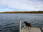
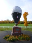
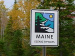
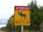
Maine – Sunday, Oct. 7
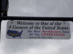
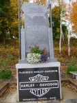
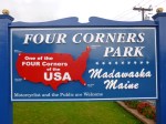
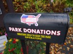
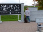
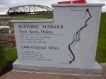
My goal today was to drive around the little circle of roads all the way up to the farthest northern part of Maine I could get too. We started off with a mile and a half walk in the state park to get warmed up, and then went to the nearby site of the launching of the first successful transatlantic hot-air balloon crossing. Then we got in the car and headed east toward the Canadian border and got out in the pretty little town of Fort Fairfield and did another 2 1/2 miles of walking. It’s still potato country around here! Then again in Van Buren I got out and walked another mile. By this time we were right on the river separating Maine from New Brunswick, and I walked down the hill almost up to the border crossing station – sort of wish I’d had my passport and Tula’s rabies papers so we could just walk into Canada, but that probably would have annoyed the crossing guards and wouldn’t have served any purpose for me other than to be able to walk into another country instead of drive! So we just turned around and walked back! It was Sunday, and it kind of unusual hearing church bells ringing from another country! There’s definitely a French background in this area. We continued along the river up to Madawaska, and I walked another mile and a half. This was a more industrial sort of town – there were paper mills (I’m pretty sure) steaming away even on a Sunday afternoon. It was a hilly town and when I walked up into the adjoining neighborhood and looked back toward the river, the view was mostly white smoke/steam in places. In town I began to notice a couple signs that made me pay attention – Madawaska was one of the 4 “corners” of the country! I knew I was as far northeast in Maine as I could get, but I hadn’t expanded that thought to realize I was in the most northeastern town of the U.S.! I thought that was pretty exciting. And I had also read earlier that Highway 1 begins in Fort Kent where I was headed next. I’ve been on Highway 1 a lot (all the way down in Key West where it ends too) and for some reason I never thought about where it actually began, and I was almost right there. It makes me feel a little dense that I don’t think of these things ahead of time, but then it’s always such a wonderful surprise when I stumble upon them! But I should try to be more aware of these things. I finished my walk and began the drive to Fort Kent – now heading south a bit. I was just as far north as I’ll be in this country until I’m in Alaska. As I was driving out of town, I noticed a big colorful sign about Four Corners Park, so I had to pull in. It was a charming park – and actually envisioned and created by motorcycle riders. Some years ago, Harley-Davidson sponsored an event where motorcycle riders had 21 days to ride their bikes to all 4 corners of the US (Madawaska, Key West, Blaine in Washington and San Ysidro in California.) In each of those places they would have to send in an envelope that they picked up from a Harley Davidson post to prove they’d been there. I guess it was quite a success and inspired them to design this wonderful little park. There were memorials and a fountain and signs explaining about the Four Corners (and I’ll be visiting the other 3!) and although Harley Davidson contributed a great deal to the design and building of the park, it was definitey a community project, and funds were needed for ongoing updates and repairs. I had found my perfect donation-of-the-day! I wrote them a little note along with the donation and left it in the locked mailbox that was conveniently there for that purpose, and I was very happy to be able to help the road-tripping cause! It didn’t take long to get to Fort Kent, although at first I had a little trouble finding any sort of marker for the beginning of Highway 1. I figured there had to be something, but wasn’t positive exactly where Highway 1 kind of merged with streets in town and then turned into a different road out of town. So as I was out walking, I asked a lady, and she pointed in the general direction, and I began to head down there, and she told me she would walk with me since the signs had been moved due to construction on the bridge to Canada (which was part of the reason I was having a little trouble finding it). Although when I saw it (set back a ways) I wondered how I could have missed it! Having driven to the end of Highway 1 in Key West years ago, it was fun to be at the very beginning of Highway 1 (and it makes me want to drive the whole thing – haha! – as if I’m not doing enough driving now. But driving the whole road at one time instead of in bits and pieces like I’m doing in completely different!!). So I enjoyed being there, and I finished up my walking in Fort Kent (and visited the very small fort – a little skirmish back in the US/Canada border dispute days). Then I got a Subway, and began the drive back south on the one main road leading down the center of northern Maine. Aroostook County (which encompasses most of northern Maine) is the biggest county east of the Mississippi and is bigger than Connecticut and Rhode Island combined. I was driving through dusk into darkness (still no moose sightings) to return to Presque Isle, where I got a motel room instead of going back to the state park to camp, because temperatures had fallen into the upper 30s and that was a bit chilly for me. So I stayed in Presque Isle for 2 nights, but in different places! It was a wonderful day.