New Hampshire – Monday, October 15
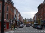
Since I had made up a couple of the miles we needed to walk today, we only had about 5 1/2 to go, plus one more donation, to finish up the state of New Hampshire. First I called the Seacoast Family Food Pantry to make sure they were open, and to see if there was anything in particular that was needed. They told me cereal and oatmeal and canned fruit would be great, plus healthy snacks. So I went shopping, and got a bunch of that stuff plus a couple other items. (The total for the food pantry was $56.08 and I used my remaining 50 cents in the parking meter in Portland!) Then I headed for downtown Portsmouth. I am not typically a big city sort of person, but I had read that it’s a historical city that in some ways is unchanged from the time it was built nearly 300 years ago. It’s right across the river from Maine. I’m so glad I came to town – Portsmouth charmed me from about the first step I took! The historical part of town (which is nearly all of it) was big, and full of solid 3-story brick buildings, many connected to each other, with 2 or 4 chimneys sprouting off each roof. There were lots of people out and about, and it’s a vibrant town full of fun little shops, cafes, galleries etc. One can only imagine the life and times this town has seen. One of the people who signed the Declaration of Independence came home from Philadelphia and planted a horse chestnut tree in 1776 and it’s still there! Lots of the sidewalks were brick and it was an easy town to walk around. Later I learned that this town came into existence with more of a commercial background (fishing) instead of the more typical religious background. Tula and I covered a couple miles walking all over downtown, then drove on a short ways and parked by a little neighborhood fish shop so we could get out and walk through one of the old neighborhoods. Again, it was fascinating to see homes that were built in the mid-1700s on a maze of narrow streets and the homes came nearly right up to the street. I like how many of them have little plaques saying when they were built and the name of the original owner. I also came upon a really old cemetery and some of the people buried there died in the 1600s – before America was even a country. Amazing.
Then we headed to the Seacoast Family Food Pantry. The 2 ladies there, Diane and Margie, were so supportive and excited about what I’m doing – they were appreciative for the food donation, and had some questions. I think if there had been room in the van for an extra person and a dog or 2, I’d have had some company! (I enjoyed meeting both of you – your reactions to my journey brightened an already bright day 🙂 Then I was off to the post office to mail the military care package that I had packed yesterday.
I enjoyed a quick drive through New Castle and was going to walk a little more, but the streets were so narrow and the houses came up within inches of them, that there was no room for walking! But I found a pretty trail at the other end of the little island – near a giant summer resort place that made me think of the Grand Hotel on Mackinac Island. A little farther south, back on the beautiful wide beach from yesterday I wrapped up the New Hampshire walking. It was time to say goodbye to New Hampshire and Hello to Rhode Island…after yet another drive through Massachusetts. It was getting dark by the time I made it into Rhode Island – drove into the state at the town of Woonsocket…just because I liked the name! No time for walking tonight – the Rhode Island adventures will begin tomorrow.


New Hampshire – Sunday, October 14
Today it was time to head for the little bit of Atlantic coast that New Hampshire has. I got packed up after staying put in the same place for 2 nights in Nashua, then I headed slightly northeast. Our first walk was in Derry, and first we got in about 3 miles – walking both around town and into adjoining neighborhoods. (I smelled someone cooking bacon! Smelled good on a Sunday morning!) Then I stopped at the house that Poet Robert Frost lived in for about 12 years – and the place where he composed many of his poems. The house was closed for the season, but I did the short half mile walk around the property and I to the woods. It was theoretically a poetry nature walk and there were about 20 markers, but with no brochure or any info, I wasn’t sure what that was all about. I thought there would be a verse here and there along the trail! I figured it was a fitting place to wander around – Robert Frost’s words “miles to go before I sleep” kind of apply to me too!


Then I was close to a place that calls itself America’s Stonehenge, but it seemed a little commercial, especially being close to Halloween they’re playing up the paranormal aspect. But they say that carbon dating the rocks has made this an ancient site of solar and lunar rock placements. Hmmmm….
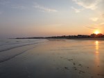
Then, the ocean! I figured I would stop at Hampton Beach State Park first, and it pretty much encompassed the whole beach area in town. There was a nice long “promenade” sort of walkway along the whole beachfront. Again, this late in the season it was relatively quiet, although quite a few people were out walking. There were dozens and dozens of motels lined up across the street from the beach – most of them with the short side facing the beach and the long side facing each other – kind of stacked like that for a mile. And then there were dozens of little shops, eating places etc. – most of which were closed. It’s hard to imagine the in-season crowds! It was a very pretty, big beach though. Dogs were not allowed down on the sand, which I totally understand. But then I was bewildered to see people riding horses along the water – they make a lot more mess (although it looked really fun!). I asked a State Park worker why horses were allowed and not dogs and at first she had no idea – but then she told me there are 2 reasons dogs are not allowed – the first one is they chase the birds, and the second one is since dogs eat beef and beef by-products, there is a possibility of E. Coli in their poop. And then she was puzzled because she thought horses also ate beef (they don’t) and we figured that was the reason horses could be on the beach and not dogs! We got a good 2 1/2 miles of walking in there. I was just following the coast road north to Portsmouth, and then I came across a beautiful sea trail with flowering shrubs, some of those little manicured trees and mansions across the street – it was called the Little Boar Ocean Walk or something like that – lots of people out enjoying that too. And then we finished off the walking (and did extra) on the prettiest beach I’ve been on yet. The tide was out and the beach expanse was huge, and it was all sandy, and there was so much room that lots of dogs were off-leash – enjoying the time as much as their humans (this was a public beach, not a state park beach) – Tula enjoyed romping around.
I had made a reservation tonight; being budget minded with money running out at the end of the week due to no camping, I wanted to make sure I got the place I wanted, and in the end I probably could have camped because it had warmed up a bit unexpectedly. But I didn’t drive by any open campgrounds anyway. I am kind of sad I didn’t get to camp in New Hampshire because I’ve camped in every other state so far. The motel was right by a big grocery store, and today was military donation today. In the morning I had sent my info to get an address – the unit this time is a medical army unit in Afghanistan, and the female soldier making the request said they’re a health-conscious group and she was asking for tuna packets, nuts and seeds and salty snacks, individual powdered drink mix tubes to pour into water bottles, herbal tea and gum, and maybe a sweet! So I got all of that, and some jerky, microwave popcorn and trail mix. I got the customs forms filled out and will mail it tomorrow.
This is my last night in New Hampshire, and at the end of the day, I have $56.58 left for tomorrow in this week’s budget – enough for my donation, and 58 cents left! Cutting it a little close this week! (It’s a good thing I have quite a few food staples on hand! Peanut butter to the rescue! And my dad is covering some breakfast expenses to get the days off to a good start, so tomorrow morning will be one of those days!)
New Hampshire – Saturday, Oct. 13
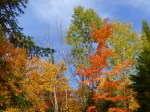
After nearly 2 weeks of not seeing much sun, it is out today and there is not a cloud in the sky! A beautiful fall Saturday. I stopped at Panera for a quick breakfast, and while I was paying, I noticed a flyer about the Anne-Marie House. When I got back in the car I read about it, and it’s a shelter in the area for families and they have nearly a 90% rate of “graduating families” getting back on their feet and being able to support themselves. The home was affiliated with a big church organization. So I called them up to see if anyone was there and if there were items in particular that they needed. Since it was a Saturday, a volunteer answered the phone – the regular staff who handles this sort of thing was not in. The volunteer didn’t really know of any specific necessities, so we decided I would get stuff like paper towels, kleenex, toilet paper, garbage bags etc that can always be used. I talked to a couple people and one of them made kind of a sad comment – he said it’s nice to get donations, and mentioned that after the holiday season, people tend to “forget” about these organizations – and I can see where that might be the case. There’s always a flurry of helping people less fortunate during the Thanksgiving and Christmas seasons, but they need the help year-round! I found a Target store and did the shopping, then drove across NAshua to find the Anne-Marie House. It was actually located on some pretty church grounds – I drove by an imposing 4-story brick convent to get there. It was a big home and we got everything carried in, and then I emailed them to let them know about the donation because I don’t think we put things in the right places! I drove past the convent and parked in the equally big Catholic school parking lot to get Tula out for a short walk because it was a pretty area. We walked down the long drives of both the school building and the convent – both are big 4-story brick structures, and the convent had a really pretty dome on the top. I hardly saw anyone out and about – one nun sweeping and another out for a walk. But there was some activity going on at the school.
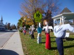
Then I set off for the southwest part of New Hampshire. AFter a bit of driving we stopped in the town of Jaffrey for a walk – there were a couple hundred homemeade scarecrows lining the streets all over town – I think there had been some kind of contest. Tula sniffed the first one and then ignored them.
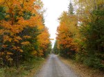
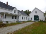
The next “town” we stopped in was Fitzwilliam, which my Triple A book had said was a classic New England town. And it was very pretty, but mostly consisted of a couple white churches, some white homes with white fences and some town offices – no shops or anything. But there were pretty country lanes leading out from the center of town and Tula and I walked nearly 3 1/2 miles along a beautiful country lane in the fall – there were lots of old low stone fences, lots of leaves to scuffle through and pumpkins, and the smell of woodsmoke from people heating their homes. The stash of wood that is lined up by some of these homes for the winter months is amazing. It was very pretty.
And then we drove over to Rindge and saw pretty much the same thing, and took another long walk on a country lane. We also passed a surprisingly large cemetery and wanderd through that – it had both old tombstones, and recent ones. Again, we saw lots of old stone walls – sometimes they were the borders of pretty green pastures, and other times they were overgrown and crumbling a bit. They’re low and I don’t know what the original purpose would have been – I don’t think they’d have been high enough to keep animals in or out, or maybe it defined property boundaries, or maybe it was simply a place to put them as settlers were clearing land.
By this time, it was beginning to get dark, and when I was in Jaffrey, I had walked past a church advertising a community pig roast dinner tonight from 5-7. I wasn’t sure I could get back there in time, but I didn’t really have lunch and a church dinner sounded good! I got there with about 10 minutes to spare


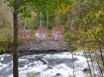


The first stop of the day today was in Franklin, which was close to where I had stopped for the night, and I had read that the town had a nice multi-purpose trail. I didn’t know where it was, but figured I’d run across it by walking around town (note to myself: look BEHIND my parking place, and sometimes what I’m looking for is right there!). Franklin was a thriving paper mill town back in the day, but now there are some empty storefronts in Main Street. I walked out by the train station – long trails sometimes seem to be along railroad tracks or rivers, but I didn’t see anything. So we then walked around the hilly town, and stopped in the little park at the other edge of town, and that’s when I saw the start of a trail under a train trestle. So Tula and I headed over and it was a wonderful wide path, and it took me a little while to realize it was another rail trail. After about the first half mile or so, I was happy to see a sign describing the “upside-down covered bridge” that was visible a little farther ahead. It was a train bridge (no longer used of course) and all the trusses and supports were beneath the tracks, so they enclosed all of that to protect it from the weather, plus capped the ends, and didn’t have to worry about the iron tracks on top. So it’s the only upside-down covered bridge still standing, even though the planks that covered the trusses are no longer there – some of them was destroyed by fire which they suspect was arson. A little farther up the river were some remnants of the footings of the old mills. With a big fast-flowing river, and railroad tracks, and bustling paper mills, it’s no wonder Franklin was a prosperous town in it’s day. Altogether I walked 3 miles on that trail (and another mile in town) and for 2 of them I could see and listen to the Winnipesaukee River with all it’s whitewater – wonderful background music! And that’s why I don’t listen to an iPod while I’m walking – I want to hear my surroundings!
When I came off the trail, I read the plaques under the train trestle, and then decided to read more about the project on the computer. The trail is about 3 miles long one way and people can access the trail from 3 different communities. Part of the reason the communities decided to make the trail was to fight their own battles with obesity and lack of exercise. And they decided an easily-accessible trail could help. There’s still work to do, and they had just held a fundraising event the night before. Although I was planning to do a food pantry donation today (but no one answered the phones when I tried calling), I changed my mind and decided to make a donation to the Winnipesaukee River Trail Fund. Not only was the trail really nice, but the reasons behind it were good ones, and I was really happy I found the trail.
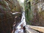
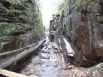
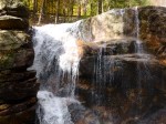
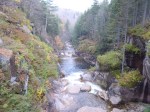
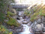
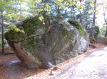
Then, since the sun was sort of out and it wasn’t raining, I decided to head north again into the mountains – I wanted to go to the Flume Gorge State Park. I had heard the trail through the gorge was spectacular, and although it’s only a 2 mile hike altogether, it involved lots of hills and lots of steps – walking down into the gorge and back out. So I got my ticket for the walk, and it was cold in the mountains – I had on my fleece, a windbreaker, a hat and fingertipless gloves so I could still take pictures. As soon as I started the walk (they have a bus that take people partway in if they want – but I just walked the whole way), white pellets started falling – I don’t know what it was – frozen snow maybe?? It wasn’t rain; it wasn’t snow; it wasn’t sleet – it was just white pellets – falling fast! The walk through the gorge truly was spectacular, and the park had built narrow boardwalks and steps along the side of the gorge above the river. Up until about the mid-1800s there also was a huge boulder wedged in at the top of the gorge (they had photos of it) and then it came crashing down during a violent storm. Going through the gorge took about the first half of the hike, and the rest was through other parts of the state park, including a huge “boulder garden” – the size of some of the boulders that the glaciers deposited there are pretty amazing. It was such a pretty hike that I decided to do the whole thing again. I was a little tired after the second go-around! Tula had to stay in the car, which was fine – dogs weren’t allowed on that trail for very good reason! The visitor center also had lots of articles about the face if the “old man of the mountain” falling off in May 2003 – it really made a lot of people around here sad. It was snowing by then (real big, pretty flakes) and once again, I knew there would be no camping tonight. I did get to see some mountaintops on the hike though – some bare granite spots up high, and snow up there too.
After 4 miles of up and down walking, I was more than happy to sit in the car and head to the south part of the state. As we went through Concord, the capital, it was just about disk, and the Capitol dome was all lit up, and it was a pretty part of town, so I got Tula out for a mile and a half walk, which gave me 9 1/2 miles for the day – I’ll use the extra mile and a half on Monday, since I didn’t get any New Hampshire walking done last Monday. Then we finished the drive to Nashua and called it a day

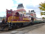


Once we were packed up, I drove the short distance to North Conway, which I knew would be a good walking town, since I’d made a short visit to the town last night. I parked at the edge of town, and Tula and I set off for what I thought was going to be a long walk. But we soon came to the train station, and a train engine was chugging, attached to historic-looking cars, and there were a bunch of people around, and I looked at the schedule and saw that an hour long train ride was going to be leaving in about 25 minutes. I couldn’t resist a short train ride through the New Hampshire countryside, especially since I had just about enough time to walk Tula back to the van. I got my ticket and even paid the extra $3.50 for a “first class” seat in the restored parlor car. Having the first class seats in that car meant everyone had a comfy wicker chair facing the train window instead of the usual bench style seats. The hour went fast, and I enjoyed being able to ride in a train again. Tula just napped in the van while I was gone – didn’t have to worry about overly warm temperatures today! Then we resumed our walk and covered 2 1/2 miles in North Conway.
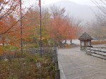
I was heading south toward my destination of the day – The Loon Center in Moultonborough. I stopped in Conway for another 2 miles of walking, then munched on some trail mix as I drove to The Loon Center which was a bit off the beaten path! My visit there was really interesting. They had a very good video with a lot of close-up footage of a nesting pair and their 2 offspring. I didn’t really know much about loons before I arrived, and knew a whole lot more about them after I left! I still don’t think I’ve ever heard or seen one in the wild, and hope to some day. I didn’t realize how low they ride in the water, and in Maine I saw some black-headed “ducks” that made me think of the anhingas I saw in Florida since I couldn’t really see their bodies, so maybe those were loons, but I’m not positive. Someday I will hear one calling! Like so many people, I am intrigued by them. I made my donation-of-the-day to the Loon Preservation Committee – which works to protect the species through education and understanding of loons and their habitats. The Loon Center had nearly 2 miles of trails that wound through the forest and along a large pond. There were lots of rocks and boulders from the last glacial age, and Tula was able to come along on those trails. In the late spring, people can sometimes see a pair of nesting loons who often come back to the same place. I didn’t see any loons – soon they’ll all be heading to the Atlantic coast where they spend the winter. The was a bench partway through the walk that overlooked the pond in the distance, along with big boulders and lots of trees. I took some time in that peaceful spot to sit down and have my own little memorial and special thoughts of my late Uncle Norm. I couldn’t be at the memorial service in South Dakota today, but I was there in spirit! Tula and I also walked another mile along the dirt road by the Loon Center.
From there we headed toward Lake Winnipesaukee, and finished off the days’ walking along the paths, boardwalks and docks by the lake in Meredith – another summer resort area that is now quiet so late in the season. I stopped at the store for some sandwich fixings and then started the search for a place to stay. It was in the low 40s by the time the sun set, and again temperatures were going to fall too low for camping (for me!). Even though my sleeping bag is good in temps down to 20 degrees, I have no desire to sleep in an unheated van when there would be frost on the windows! It took some time to find a pet-friendly place – I stopped at a good half dozen places before finding one that Tula and I could stay at. But, I knew that would happen now and then, and although it began to get a bit discouraging, I can certainly understand that not everyone wants a dog around!
New Hampshire – Wednesday, Oct. 10
We started the morning off with a 3.2 mile walk around Lancaster and adjoining neighborhoods (different parts of town than I’d been in yesterday). I had done a little research last night and saw that there was a homeless shelter in Lancaster, and I was hoping to make a donation to them. So I called, but just got the answering machine – and I’m really hesitant to shop and just leave stuff on the doorstep in case the place might not be in business anymore. I ended up calling a tri-county shelter office in a town about 45 minutes away to see if maybe I should give them the donation. The guy I spoke with there knew the manager of the Lancaster place (the Tyler Blaine House) and called him and tracked him down. In the end, the manager of the Tyler Blaine house told the other guy he would be back soon and would be happy to get anything at all – and perhaps some milk and eggs would be nice. So I did my shopping – and for the first time got some perishable stuff along with the usual non-perishable things. I found the house (and had actually walked by it in the morning without noticing the sign!) and they helped unload the bags and were pleased to get the stuff.
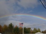
Then I started to head south toward the White Mountains. It was kind of a cloudy day, and we stopped in the town of Whitefield, and did about 2 1/2 miles of walking and got rained on a bit – it wasn’t a downpour or anything, but still a bit wet and chilly! Then I headed down to Twin Peaks, the next town, and decided I better quickly finish my last couple miles of walking because there were some dark clouds moving in even though the sun was out right where I was at. As soon as I parked the car and got out, I saw a huge beautiful rainbow – the complete arc leading right down to the ground by a house about 1/2 mile up. I figured if I really hurried I would find my pot of gold at the end of the rainbow! So we set off down the straight sidewalks on the straight street and it seriously looked as though I should be able to walk right under the rainbow. Oddly enough, the closer I got, the more the rainbow retreated, and even though I chased it down for over a mile, I failed in my attempt to retrieve the pot of gold! I began to wonder a bit about the physics of rainbows (if I saw the rainbow while walking north, I assumed the people driving south could see the same thing…and at some point, if they drove by me, they must have passed under the rainbow) and then it just got all confusing and I decided to just enjoy the magic of a big pretty rainbow – and for a while there was a faint second rainbow too – a double arch! It was beginning to sprinkle when we got back to the car and the wind was picking up.
At this point I should have been able to see the peaks of a lot of the mountains in the Presidential Range, but no such luck. Mt. Washington is the tallest mountain in New England (biggest mountain north of the Carolinas and east of the Mississippi) and I haven’t seen it yet – and I’m sure it’s because I haven’t seen a whole lot of the sun lately either! This is a big receation/resort area, and winter skiing is the main attraction (although in the summer there’s rock climbing, hiking, kayaking and canoeing) and there’s lots of ski resorts and lodges and inns. I drove by an enormous resort that has been there since before World War 11. Back in those days, the wealthy people would take a train into the mountains, and sometimes 50 trains a day would arrive at the resort, and many families had their own private railroad car(s) which would stay on sidings until they were ready to leave again – it’s hard to imagine a life like that! A lady at the train museum also told me that WW11 military units would train for winter/mountain combat in the White Mountains (in white camo) because the rugged terrain was similar to some of the mountain terrain in Europe.

It started to rain more heavily, and then started coming down in a downpour, and although the drive through the White Mountain National Forest was pretty, I was pretty much just concentrating on driving through the rain. When I came out on the south end of the national forest, there were more little towns and I decided to stop in Intervale because it was now getting dark in addition to the rain. I got a reasonable room at the first stop (no charge again for Tula) and am beginning to wonder if I’ll be able to camp at all in New Hampshire! This has been the chilliest state so far, and then there’s been quite a bit of rain too. I was hoping to camp at least once in each of the states, so I’ll just have to see what the rest of the week holds.
New Hampshire – Tuesday, Oct. 9
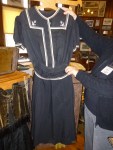
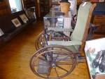
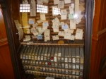
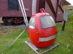
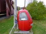
Now I’m ready to see New Hampshire in the daylight! I started the day off with a 2 1/2 mile walk all around Gorham. This town is the entrance to the “Great North Woods” part of the state. As often happens, my walking took me by a train station – many of the stations we walk by in these small towns are no longer used, but this one had been turned into a little train and town museum, and I knew I’d have to stop in there after my walk! It was a fun little museum and the lady there showed me all around and told me a lot about the displays. I think I would have liked to be a station manager back in the day – watching the trains go by; selling the tickets out of a cool machine with wooden balls and a different ticket for each destination, and taking care of telegraph messages. (I included a picture of the ticket dispenser, a ladies’ bathing suit from the ’30s/’40s and an old wheelchair). One of the things I was hoping to see in New Hampshire was the “old man of the mountain” profile that’s pictured on the backs of the New Hampshire state quarters. But the lady at the museum told me the “face” fell off the mountain 9 years ago! One of the trademarks of the state no longer exists. Mother Nature designed the profile, and Mother Nature took it away. Outside of the museum there was a small little capsule shaped ski-lift chair – one of the first lifts from back in the 50s at a local ski mountain. I can’t imagine anyone today would be willing to get in that thing! It was so small that the skis had to be put in a metal band on the outside of the lift. But people probably loved it then because they didn’t have to climb up the mountain! There’s a picture of that too – and it was small!
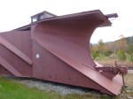
New Hampshire gets a lot of snow and they also had a train track plow outside – it had to be pushed by an engine, but it would remove a lot of snow!
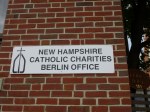
I had a discount voucher for a cute little coffee shop, so I stopped in for some quiche and a cinnamon roll, and fortified by that, I was ready to sort out my donation of the day. I decided to do a food pantry donation, and found the Good Shepard Parish in Berlin, about 10 miles north, and called them to see what they needed. The lady I spoke with mentioned the typical peanut butter, boxed dinners, pasta and veggies and stuff. So I found a Wal-Mart and loaded up the cart. When I got up to Berlin, I think I mixed up which church the parish office belonged to, because I couldn’t find any offices or people – and I was at some huge church. So I called them again, and they were located about 1/2 mile down the road. I unloaded the goodies, and then did a couple miles of walking in Berlin. I was going to do more, because at first glance I thought this would be a good town to walk in, but as it turned out, there were lots of one way streets at odd angles on the hills with other streets, and it was kind of an industrial town and there were lots of trucks hauling logs, and I cut the walk a little short. Speaking of trucks with logs, they are a very common sight, both in northern Maine and here. There was a paper mill up in northern Maine, and then farther south I saw s huge place where the trees become lumber, and I’m not sure what they were doing with the trees in Berlin, but seeing sooooo many trucks loaded down with cut trees kind of makes one stop and think a bit.
Then, I backtracked a little and went to Moose Brook State Park, and that was much better, even if one of the trails was closed for the season. I got another mile and a half of walking in there. Then I continued to head west through the mountains, almost to the border of Vermont, to the town of Lancaster. And that was a fun town to walk in – we walked a couple more miles to finish off the walking for the day, and I knew there would be more good walking in the morning, so we stayed in Lancaster because I hadn’t decided if I was going to head just a little farther north, or head down to the White Mountains.
It was nice to be settled in at a reasonable hour, and I spent quite a bit of time on the phone – mostly talking to one of my aunts. My last surviving uncle passed away early Monday morning, and I had made a very difficult decision to not head to South Dakota for the funeral. But it was nice to have some time on the phone with my aunt while her house was quiet before other people started arriving. I will have a quiet moment of remembrance in some special place on Thursday morning when the memorial service is happening.
Maine – Monday, Oct. 8
I had a lot of driving to do today since I was still pretty far north in Maine. The benefit of camping 4 nights in Maine allowed me to have extra gas money to roam all over the state! I didnt do a donation today, because of the double donation last Tuesday – all 7 Maine donations are done. And I still had a bit of walking to do – 6.8 miles left from last Monday, and about a mile and a half left from one of the rainy days.
So, my first place to walk today was in Presque Isle – since I had stayed 2 nights in this neck if the woods, I figured I better walk around and see the town a bit! First I stopped at a laundromat to get some clothes washing while we walked. I went back to get them in the dryer and we walked some more. We covered 3.3 miles, and after a quick stop at a gas station to put air in all my tires (a buzzer had come on indicating tire pressure was about 5 pounds low in each tire. It was the coldest night of the trip so far, but I don’t know if that would cause low tire pressure.) I put air in, and everything has been fine since, and I headed south with everything clean. It was a pretty drive through the mountains with long ups and downs through peaks and valleys – and pretty colors. I pulled off for a good view of Mt. Katahdin – less cloudy that it was a few days ago. We stopped in the town of Patten and walked another 2.2 miles. Eventually I picked up I-95 and stayed on that until I was a little west of Bangor. Then I had to make a decision about which way to go. My preference was to enter New Hampshire toward the north end of the state. But that’s the Great North Woods part of the state, and I didn’t want to do too much driving in the dark when I got into New Hampshire. So I called ahead and was able to make a reservation in Gorham, only about 8 miles from the state line. Knowing I had a place to stay in New Hampshire gave me the freedom to take my time on a 2-lane road across western Maine. I stopped in the town of Skowhegan to fill up with gas and finish my walking before it got dark. I came into Maine with only about 1/3 tank of gas, and despite all the miles driven, I was able to leave Maine with a full tank of gas! I still had a little money leftover in my weekly budget, so I figured it was time to get more dog food and treats, and some staples for me. After I bought what I needed, I still had a little money left, and I put that into the United Way container at the checkout.
I still had some miles to go in Maine, but a little after 9pm we crossed into State #6 – New Hampshire! Maine was a success – 7 donations given; 56 miles walked; and 1098 miles driven.
Once in New Hampshire, I only drove the 8 miles to Gorham and got checked in. This was my latest arrival into a state and needless to say, I didn’t get any walking done! It’s pretty cold here in the mountains – in the upper 30s and I was happy to have a warm room waiting. The motel has been around for a while – I’m guessing since the 60s or so, but it had been well maintained, and it happily reminded me of traveling in my youth. And 2 trains passed during the night – I like the whistles and the clatter of the tracks.

Maine – Sunday, Oct. 7
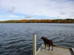
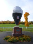
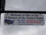
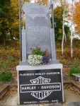
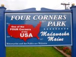
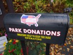
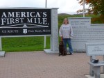
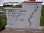
My goal today was to drive around the little circle of roads all the way up to the farthest northern part of Maine I could get too. We started off with a mile and a half walk in the state park to get warmed up, and then went to the nearby site of the launching of the first successful transatlantic hot-air balloon crossing. Then we got in the car and headed east toward the Canadian border and got out in the pretty little town of Fort Fairfield and did another 2 1/2 miles of walking. It’s still potato country around here! Then again in Van Buren I got out and walked another mile. By this time we were right on the river separating Maine from New Brunswick, and I walked down the hill almost up to the border crossing station – sort of wish I’d had my passport and Tula’s rabies papers so we could just walk into Canada, but that probably would have annoyed the crossing guards and wouldn’t have served any purpose for me other than to be able to walk into another country instead of drive! So we just turned around and walked back! It was Sunday, and it kind of unusual hearing church bells ringing from another country! There’s definitely a French background in this area. We continued along the river up to Madawaska, and I walked another mile and a half. This was a more industrial sort of town – there were paper mills (I’m pretty sure) steaming away even on a Sunday afternoon. It was a hilly town and when I walked up into the adjoining neighborhood and looked back toward the river, the view was mostly white smoke/steam in places. In town I began to notice a couple signs that made me pay attention – Madawaska was one of the 4 “corners” of the country! I knew I was as far northeast in Maine as I could get, but I hadn’t expanded that thought to realize I was in the most northeastern town of the U.S.! I thought that was pretty exciting. And I had also read earlier that Highway 1 begins in Fort Kent where I was headed next. I’ve been on Highway 1 a lot (all the way down in Key West where it ends too) and for some reason I never thought about where it actually began, and I was almost right there. It makes me feel a little dense that I don’t think of these things ahead of time, but then it’s always such a wonderful surprise when I stumble upon them! But I should try to be more aware of these things. I finished my walk and began the drive to Fort Kent – now heading south a bit. I was just as far north as I’ll be in this country until I’m in Alaska. As I was driving out of town, I noticed a big colorful sign about Four Corners Park, so I had to pull in. It was a charming park – and actually envisioned and created by motorcycle riders. Some years ago, Harley-Davidson sponsored an event where motorcycle riders had 21 days to ride their bikes to all 4 corners of the US (Madawaska, Key West, Blaine in Washington and San Ysidro in California.) In each of those places they would have to send in an envelope that they picked up from a Harley Davidson post to prove they’d been there. I guess it was quite a success and inspired them to design this wonderful little park. There were memorials and a fountain and signs explaining about the Four Corners (and I’ll be visiting the other 3!) and although Harley Davidson contributed a great deal to the design and building of the park, it was definitey a community project, and funds were needed for ongoing updates and repairs. I had found my perfect donation-of-the-day! I wrote them a little note along with the donation and left it in the locked mailbox that was conveniently there for that purpose, and I was very happy to be able to help the road-tripping cause! It didn’t take long to get to Fort Kent, although at first I had a little trouble finding any sort of marker for the beginning of Highway 1. I figured there had to be something, but wasn’t positive exactly where Highway 1 kind of merged with streets in town and then turned into a different road out of town. So as I was out walking, I asked a lady, and she pointed in the general direction, and I began to head down there, and she told me she would walk with me since the signs had been moved due to construction on the bridge to Canada (which was part of the reason I was having a little trouble finding it). Although when I saw it (set back a ways) I wondered how I could have missed it! Having driven to the end of Highway 1 in Key West years ago, it was fun to be at the very beginning of Highway 1 (and it makes me want to drive the whole thing – haha! – as if I’m not doing enough driving now. But driving the whole road at one time instead of in bits and pieces like I’m doing in completely different!!). So I enjoyed being there, and I finished up my walking in Fort Kent (and visited the very small fort – a little skirmish back in the US/Canada border dispute days). Then I got a Subway, and began the drive back south on the one main road leading down the center of northern Maine. Aroostook County (which encompasses most of northern Maine) is the biggest county east of the Mississippi and is bigger than Connecticut and Rhode Island combined. I was driving through dusk into darkness (still no moose sightings) to return to Presque Isle, where I got a motel room instead of going back to the state park to camp, because temperatures had fallen into the upper 30s and that was a bit chilly for me. So I stayed in Presque Isle for 2 nights, but in different places! It was a wonderful day.
Maine – Saturday, Oct. 6
I knew today would need to be my military donation – I realized last night that Monday is Columbus Day and since I often mail my military packages on a Monday, I knew I’d have to get it out today if I wanted to mail a package from Maine. To complicate matters, I was so close to Canada that my phone and iPad thought I was “abroad”, and I needed to email an address request. So I went to McDonald’s for breakfast (the oatmeal with apples was actually pretty good!) to take advantage of their wireless services. I emailed my address request and eventually got the response. The unit I’m mailing a care package to this week is a navy unit actually on an aircraft carrier somewhere. The request was from a female Navy person who said everyone liked to have something to read…some of the soldiers were on their first cruise and were a bit homesick…and the women would like some “girly” stuff like body washes and lotion. So I got magazines and puzzle books, body washes and lotions, deoderant and shaving cream; lip balm and gum. I can’t spend quite as much on my military donations because I have to remember there’s also a $13.45 shipping fee which has to be part of the $56 donation. I found a post office, and got the paper work done and got it mailed off 15 minutes before the post office closed.
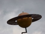
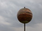
Somehow that had taken a good chunk of the morning, and I was eager to get out walking because the skies were looking pretty gray again. My plan was to drive straight north along US 1, stopping to look at the largest scale model of the solar system too (thank you to Joe K for telling me about this!). The scale was 1 mile = 1 astronomical unit (which a brochure reminded me was 93 million miles which is the distance between the sun and the earth.) So in this case, the earth and sun were 1 mile apart, and Pluto and the sun were 40 miles apart. This really all helped to put the solar system in perspective in understandable terms. I started at the Pluto end and worked my way north. The Univ. of Maine students who made this also kept the size of the planets in scale, and Pluto was just a tiny little 1 inch ball, and the sun is so big by comparison that only a portion of its curve takes up the whole first floor in the science building at the university. Along the way on our trip through the solar system, Tula and I got out to walk a mile in a tiny little town, and then I found part of the rail trail that I knew was there somewhere, and we walked 4 miles – 2 miles straight out into the Maine wilderness, and 2 miles back. I was in good moose territory – passing by some marshy areas, but didn’t see any. This part of Maine is also potato country and on the drive north I passed countless potato fields, and there were stands alongside the road selling 50# of potatoes for $10.
As I got closer to Presque Isle, I was able to get a picture of Venus, but by the time I found Mercury, it was pouring rain. It was getting to be late afternoon anyway, and I stopped by a couple of the motels in town, but neither were quite in the budget range. I drove up to Caribou, but the town seemed almost deserted (I guess rain can do that though!). Even though I couldn’t make phone calls, I was able to check the weather on my phone, and it said the rain would begin to end during the night. I decided to do my other 3 miles of walking in the pretty-good-sized shopping mall in Presque Isle so I did 6 laps of the inside of the mall. By this time, it wasn’t raining quite so hard, so I picked up some Chinese food at the Food Court and headed just south of Presque Isle to Aroostook State Park (Maine’s first and oldest state park!). I drove there in the dark and light rain, and got myself registered, and set up in record time without getting too wet. It was cozy in the van with the light rain, and somewhere along the way I was woken up by bright moonlight shining in on me, and I knew the rain had passed.